The weekend forecast for Sebastian appears to be holding steady from yesterday’s projections, with scattered thunderstorms expected across the region. Daytime highs are anticipated to reach the mid-80s, with temperatures dipping to approximately 70 degrees during the evening.
Be sure to closely monitor our Sebastian Calendar due to the unstable weather conditions. Any event changes or cancellations will be updated promptly on the calendar listing.
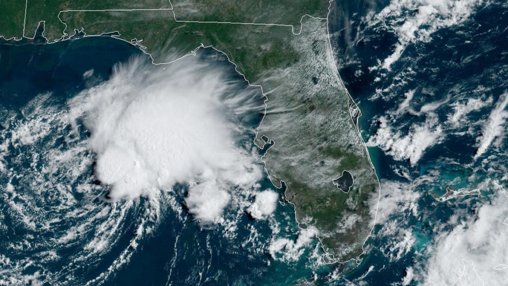
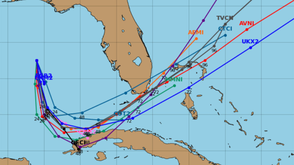
The city’s prevailing winds currently originate from the northeast, pushing the newly formed Tropical Depression Two further south. The tropical disturbance that developed yesterday is predicted to intensify and earn the title of Tropical Storm Arlen in the coming days. After that, however, forecasts suggest it will weaken again before reaching Cuba.
As of Friday morning, the developing storm was located approximately 285 miles west of Ft. Myers, Florida. Maximum sustained winds were reported to be around 35 mph. Throughout the weekend, the weather system is set to veer back towards the north, which will likely bring additional rainfall to our area as we head into the following week.
June 1st marked the start of the hurricane season, which will run through November 30th. The formation and movement of these disturbances toward the coastline are a regular, yearly phenomena that can often pose challenges. The majority of these weather systems tend to originate from the east rather than the west, making the area particularly vulnerable to such storm events.
But living in Sebastian, Florida, isn’t all about storms. Despite the weather predictions, various outdoor activities are still available this weekend. Regardless of the forecasted rain or shine, the city offers many attractions, including boating, fishing, or attending a wide array of live entertainment. The community is encouraged to make the most of the weekend while remaining alert to weather changes.
The East Coast of Florida is particularly prone to hurricanes due to its geographical location and tropical climate,.
- Florida Keys: This string of islands is often the first area hit when hurricanes approach from the southeast. It’s very vulnerable due to its low-lying land.
- Miami-Dade and Broward Counties: These are among the most populous areas in Florida and are highly vulnerable to hurricanes. Miami, Fort Lauderdale, and surrounding areas have experienced some of the most powerful hurricanes.
- Palm Beach County: Like Broward and Miami-Dade, Palm Beach County is at high risk due to its coastal location.
- Treasure Coast: This region includes Martin, St. Lucie, and Indian River counties. Its eastern exposure makes it particularly vulnerable to Atlantic hurricanes.
- Space Coast: The Space Coast, including cities like Melbourne and Titusville and the Kennedy Space Center, is highly exposed and at risk.
- Daytona Beach: As another coastal city, Daytona Beach is often in the direct path of hurricanes.
- St. Augustine and Jacksonville: The northernmost cities on Florida’s east coast, St. Augustine and Jacksonville, are also prone to hurricanes, though the risk decreases slightly as one moves north.
It’s important to note that hurricane impacts are not limited to coastal areas. The size and strength of a hurricane can lead to significant impacts inland as well, affecting counties in the central part of the state.