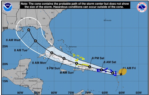
Tropical Storm Laura formed this morning in the Atlantic and is expected to strengthen to a category one hurricane by Tuesday as it moves across South Florida and enters the Gulf of Mexico.
In Sebastian, we can expect maximum sustained winds of 20 to 30 mph with higher gusts if Laura continues on its current path. We can also expect more rain, which is concerning since there’s a lot of recent flooding in Sebastian.
The forecast and path of Tropical Storm Laura can also change.
A tropical storm warning has been issued for Puerto Rico and the U.S. Virgin Islands. Tropical storm conditions are possible across portions of the northern Leeward Islands, the Virgin Islands, Puerto Rico, the southeastern Bahamas, and the Turks and Caicos Islands later today through Saturday night.
“The official forecast calls for some slow strengthening during the next couple of days, but the intensity forecast is quite uncertain and depends on how much interaction with land will occur. For now, we will assume that the northern part of the circulation will remain over water so that the system will not be too disrupted by Hispaniola and Cuba. The official intensity forecast remains close to the model consensus except at days 4 and 5 where it is a little lower due to these uncertainties,” the National Hurricane Center said in a statement.
The storm is located 210 miles of the Leeward Islands with maximum sustained winds of 45 mph. It is moving west at 18 mph.
A Tropical storm warning means that tropical storm conditions are expected somewhere within the warning area within the next 12 to 24 hours.
Sebastian Daily will continue to monitor Tropical Storm Laura and will provide further updates when they are available.