Tropical Storm Ian’s path has shifted slightly back to the east, but as we said in today’s Sebastian newscast, we can expect this storm to wobble back and forth. Forecasters are predicting a Category 3 or 4 landfall somewhere on the west coast of Florida.
In Sebastian, we’ve been in and out of the “cone of uncertainty” all day. Ian is a large storm, about 400 miles across, and is beginning to show signs of hurricane development.
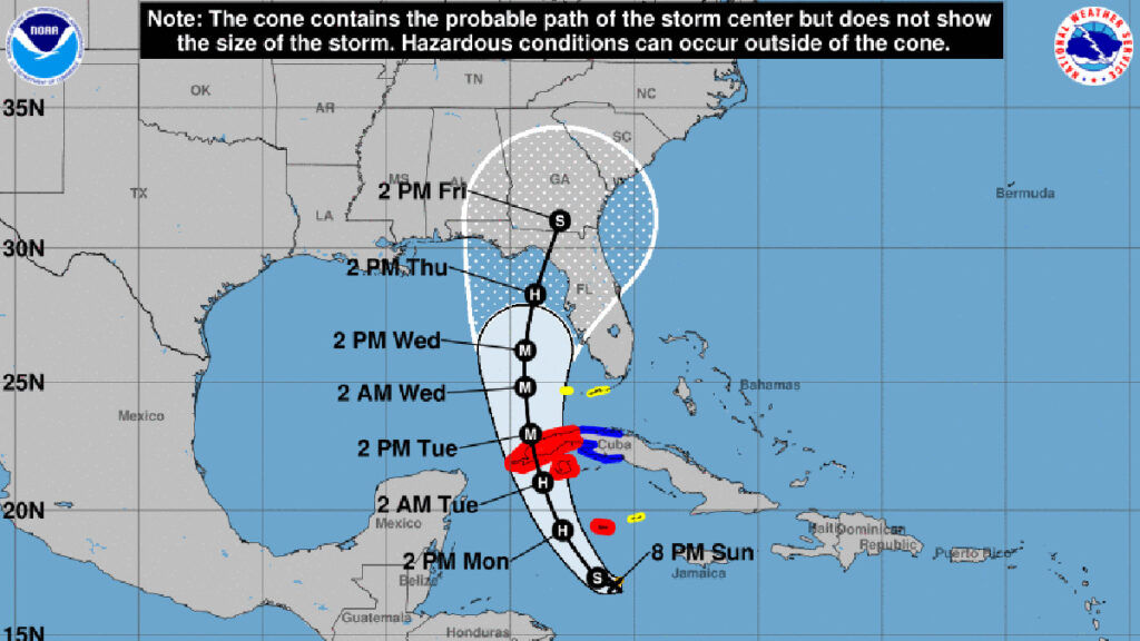
As of 8:00 p.m., all of the tracking models show a move toward the east, of the west coast of Florida. The National Hurricane Center (NHC) said Ian is expected to become a hurricane on Monday and a major hurricane on Tuesday.
“Ian is expected to be a major hurricane in the eastern Gulf of Mexico during the middle of this week, but uncertainty in the track and intensity forecasts remains higher than usual.”
Forecasters say Ian will become a Category 4 hurricane while in the Gulf of Mexico but will downgrade to a Category 3. The tropical storm is currently moving northwest at 12 mph with maximum sustained winds of 60 mph.
The center of Ian is expected to pass near the Cayman Islands on Monday and near the western portion of Cuba by Monday night and into Tuesday morning. Ian is then expected to enter the Gulf of Mexico late Tuesday.
In Sebastian, our weather will begin to change Monday night and into Wednesday with tropical storm conditions. It’s a good idea to prepare for this hurricane no later than Tuesday.
Sebastian Daily will keep you updated on any threats to our local area.