
Tropical Storm Erin is moving steadily westward across the central Atlantic Ocean and is forecast to intensify into a hurricane by Thursday night or early Friday, according to the National Hurricane Center.
It’s too early to predict if the storm will threaten Sebastian or Vero Beach, but long-term weather models suggest it may veer out to sea.
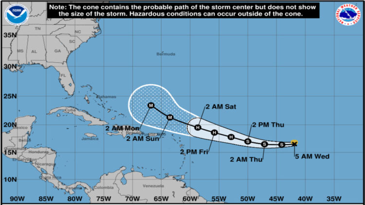
According to the National Hurricane Center’s (NHC) 5:00 AM AST advisory, the storm is currently located at 16.5°N, 41.9°W, approximately 1,400 miles east of the northern Leeward Islands, packing maximum sustained winds of 45 mph and moving west at 20 mph.
Current Status and Forecast
Erin, the fifth named storm of the 2025 Atlantic hurricane season, is expected to maintain its westward trajectory through Thursday before shifting to a west-northwest path by Thursday night.
This track could bring the storm near or just north of the northern Leeward Islands, Virgin Islands, and Puerto Rico by the weekend.
While no coastal watches or warnings are currently in effect, forecasters continue to monitor the storm’s progress closely.
The NHC forecasts gradual strengthening, with Erin likely to reach hurricane status—defined as sustained winds of at least 74 mph—within the next couple of days. Favorable conditions, including warm ocean waters and conducive atmospheric patterns, are expected to support this intensification.
Some models suggest Erin could become a major hurricane (Category 3 or higher, with winds exceeding 111 mph) by Sunday, August 17.
Potential Impacts
While it is too early to determine the exact impacts on land, Erin is expected to generate swells that will begin affecting the northern Leeward Islands, Virgin Islands, and Puerto Rico by the weekend. These swells could lead to life-threatening surf and rip current conditions along coastlines.
Local weather offices are advising residents and visitors to stay informed and take precautions, particularly at beaches, where rip currents can pose significant dangers.
Before its designation as a tropical storm, Erin brought heavy rainfall to the Cabo Verde Islands, resulting in at least seven fatalities and significant damage. The storm’s rapid westward movement, faster than 97% of similar storms in this region, has limited the spread of its tropical-storm-force winds, which currently extend up to 60 miles from the center.
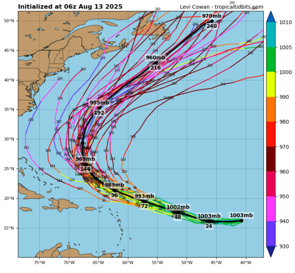
Uncertainty in Long-Term Track
The long-term path of Erin remains uncertain, with computer models showing a range of possibilities. Most models indicate a northward turn as Erin approaches the Caribbean, potentially keeping it parallel to the U.S. East Coast and reducing the likelihood of a direct U.S. landfall.
However, meteorologists caution that small shifts in the storm’s trajectory could alter its impacts on the Greater Antilles, the Bahamas, Bermuda, or the U.S. East Coast next week. AccuWeather forecasters have noted potential for heavy rain and wind gusts of 40–60 mph in northern Puerto Rico, with isolated gusts up to 80 mph possible.
Preparation and Safety
The NHC emphasizes that it is too soon to predict specific impacts, but residents in potentially affected areas should prepare for the possibility of hazardous conditions.
The Atlantic hurricane season, which runs from June 1 to November 30, is approaching its climatological peak around September 10, making preparedness critical. Authorities recommend reviewing hurricane plans, assembling disaster supplies, and staying updated with local weather alerts.
Stay tuned to Sebastian Daily for local weather and Tropical Storm Erin updates.
