
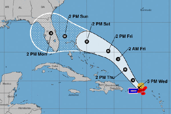
Hurricane Dorian’s path has changed multiple times since Monday, and as of Wednesday night, Sebastian is one of the cities in its direct path. However, it’s important to remember that Dorian’s current path will change again.
Residents living in and around Sebastian are watching the Weather Channel or getting their information from third-party independent forecasters. They are getting upset by what they see.
Please know that the information used to report the hurricane on the Weather Channel and independent forecasters is no different than what we use here at Sebastian Daily. We stay focused on what the National Hurricane Center says, and we are following the tracking that’s published by NOAA. We do this without adding our two cents and opinions.
More importantly, we are right here in Sebastian. We’re not in Miami, or Pensacola, or New York. We are right here in this town providing local coverage as we’ve done in the past.
All of us here at Sebastian Daily have been through major hurricanes. We were here during Hurricane Frances, Hurricane Jeanne and many others.
Now, after saying that, we want everyone in Sebastian to know that the storm track for Dorian will change again. We do not know, just like other forecasters and TV stations, where Dorian will make landfall.

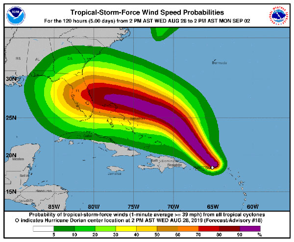
One of the things we like to look at is the Wind Speed Probabilities from NOAA. The wind speed chart will tell us what we can expect in Sebastian at the time NOAA publishes the advisory. As of tonight, it’s looking like we will experience winds of 80-90 mph. Again, this can change by tomorrow.
Hurricane Dorian’s track and cone has changed three times today. When you see the current tracking, don’t fret. It will most likely change again.

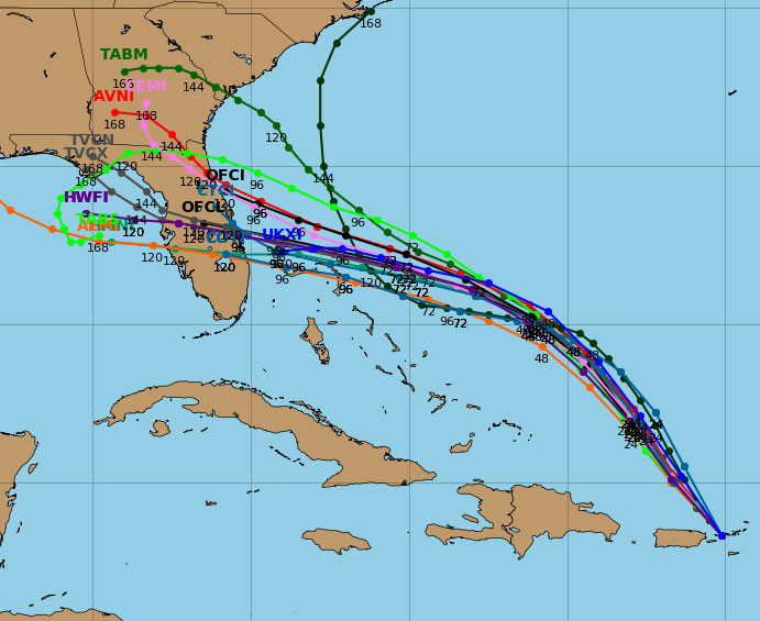
The other thing we like to look at are the computer generated models that predict where Hurricane Dorian might be heading. These are also called the spaghetti models for Hurricane Dorian.
The models are not 100 percent accurate, but they tell us where the storm might be heading. As of Wednesday night, most of the spaghetti models agree that Dorian will make landfall somewhere in Florida.
Dorian is currently 45 miles of St. Thomas moving at 14 mph with 80 mph maximum sustained winds. During the next 24 to 48 hours (Thursday and Friday), it will continue to move northwest before turning west-northwest toward Florida.
“All indications are that by this Labor Day weekend, a powerful hurricane will be near or over the Florida peninsula. The new NHC track forecast is a little bit to the south of the previous one, given that global models have a stronger ridge to the north and the track models show more of a westward motion,” the National Hurricane Center said in a statement.
We suggest waiting to see what this storm does by tomorrow and Friday.
We will begin our LIVE videos tomorrow and throughout the weekend on our website at SebastianDaily.com, Facebook, and our YouTube channel.
Our live coverage area will include Grant, Barefoot Bay, Micco, Sebastian, Fellsmere, and Vero Beach. We will be reporting of any local shelters that are open, and where to get supplies and sandbags if needed.
We will publish another update Thursday morning.