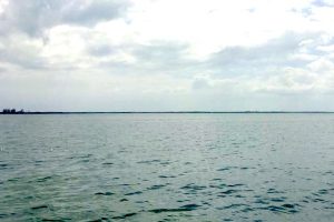
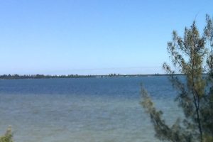
High Surf Advisory issued April 7 at 2:16AM EDT until April 9 at 8:00PM EDT by NWS Melbourne FL
Affected Areas: Coastal Indian River; Mainland Southern Brevard; Southern Brevard Barrier Islands
* WHAT...For the High Rip Current Risk, dangerous rip currents. For the High Surf Advisory, large breaking waves of 8 to 12 feet expected in the surf zone.
* WHERE...Coastal Indian River, Mainland Southern Brevard and Southern Brevard Barrier Islands Counties.
* WHEN...For the High Rip Current Risk, through late Friday night. For the High Surf Advisory, from 5 PM this afternoon to 8 PM EDT Thursday.
* IMPACTS...Dangerous swimming and surfing conditions and localized beach erosion. Rip currents can sweep even the best swimmers away from shore into deeper water.
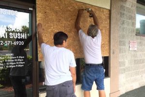
High surf will affect the beaches in the advisory area, producing localized beach erosion and dangerous swimming conditions. Swimmers should remain out of the water due to large breaking waves and dangerous surf conditions. Rip currents are powerful channels of water flowing quickly away from shore, which occur most often at low spots or breaks in the sandbar and in the vicinity of structures such as jetties and piers. Heed the advice of lifeguards, beach patrol flags and signs. Entering the surf is strongly discouraged. If caught in a rip current, relax and float. Don't swim against the current. If able, swim in a direction following the shoreline. If unable to escape, face the shore and call or wave for help.
Rip Current Statement issued April 7 at 2:16AM EDT until April 11 at 2:00AM EDT by NWS Melbourne FL
Affected Areas: Coastal Indian River; Mainland Southern Brevard; Southern Brevard Barrier Islands
* WHAT...For the High Rip Current Risk, dangerous rip currents. For the High Surf Advisory, large breaking waves of 8 to 12 feet expected in the surf zone.
* WHERE...Coastal Indian River, Mainland Southern Brevard and Southern Brevard Barrier Islands Counties.
* WHEN...For the High Rip Current Risk, through late Friday night. For the High Surf Advisory, from 5 PM this afternoon to 8 PM EDT Thursday.
* IMPACTS...Dangerous swimming and surfing conditions and localized beach erosion. Rip currents can sweep even the best swimmers away from shore into deeper water.
High surf will affect the beaches in the advisory area, producing localized beach erosion and dangerous swimming conditions. Swimmers should remain out of the water due to large breaking waves and dangerous surf conditions. Rip currents are powerful channels of water flowing quickly away from shore, which occur most often at low spots or breaks in the sandbar and in the vicinity of structures such as jetties and piers. Heed the advice of lifeguards, beach patrol flags and signs. Entering the surf is strongly discouraged. If caught in a rip current, relax and float. Don't swim against the current. If able, swim in a direction following the shoreline. If unable to escape, face the shore and call or wave for help.
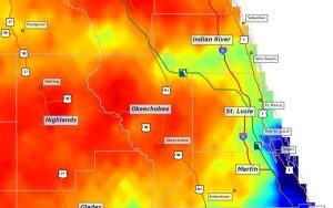
Flood Watch issued April 7 at 1:58AM EDT until April 7 at 8:00PM EDT by NWS Melbourne FL
Affected Areas: Coastal Indian River; Coastal St. Lucie; Coastal Martin; Inland Indian River; Inland St. Lucie; Inland Martin
* WHAT...Flooding caused by excessive rainfall continues to be possible.
* WHERE...A portion of east central Florida, including the following counties, Indian River, Martin, Saint Lucie.
* WHEN...Through this evening.
* IMPACTS...Excessive runoff may result in flooding of rivers, creeks, streams, and other low-lying and flood-prone locations.
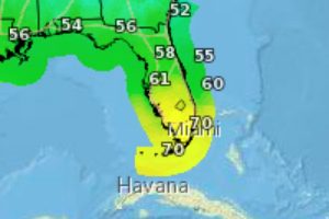
* ADDITIONAL DETAILS... - Slow-moving bands of rain are forecast to increase over the watch area today in response to weak low pressure developing along a stalled front. Mostly likely rainfall tallies of 2 to 4 inches are expected with isolated amounts of 5 to 7 inches. - http://www.weather.gov/safety/flood
You should monitor later forecasts and be alert for possible Flood Warnings. Those living in areas prone to flooding should be prepared to take action should flooding develop.
Wind Advisory issued April 6 at 11:50PM EDT until April 8 at 8:00AM EDT by NWS Melbourne FL
Affected Areas: Coastal Indian River; Coastal St. Lucie; Inland Indian River; Inland St. Lucie
* WHAT...Northeast winds 15 to 25 mph with gusts up to 45 mph expected.
* WHERE...Coastal Indian River, Coastal Saint Lucie, Inland Indian River, and Inland Saint Lucie.
* WHEN...From 5 PM Tuesday to 8 AM EDT Wednesday.
* IMPACTS...Gusty winds will blow around unsecured objects. Tree limbs could be blown down and a few power outages may result.
* ADDITIONAL DETAILS...The strongest gusts are expected at the coast.
Winds this strong can make driving difficult, especially for high profile vehicles. Use extra caution.