The National Oceanic and Atmospheric Administration (NOAA) says the 2019 Atlantic Hurricane Season will be busier than expected due to El Niño conditions.
Sebastian Daily will be informing the local public of any threats to our area. We do not report on tropical disturbances, tropical depressions, tropical storms, or hurricanes unless they threaten South Brevard or Indian River County.
Seasonal forecasters with NOAA’s Climate Prediction Center have increased the likelihood of an above-normal Atlantic hurricane season to 45% (up from 30% from the outlook issued in May). The probability of near-normal activity is now at 35%, and the chance of below-normal activity has dropped to 20%.
“NOAA will continue to deliver the information that the public depends on before, during and after any storms throughout the hurricane season,” said Neil Jacobs, Ph.D., acting NOAA administrator. “Armed with our next-generation satellites, sophisticated weather models, hurricane hunter aircraft, and the expertise of our forecasters, we are prepared to keep communities informed to help save lives and livelihoods.”
El Niño conditions favor increased wind shear and reduced hurricane activity. However, NOAA forecasters have determined that El Niño conditions have ended. Hurricane conditions are now more favorable for above-normal hurricane activity. The most active part of the season is September and October.
The number of predicted storms is also greater with NOAA now expecting 10-17 named storms (winds of 39 mph or greater), of which 5-9 will become hurricanes (winds of 74 mph or greater), including 2-4 major hurricanes (winds of 111 mph or greater). The updated outlook is for the entire six-month hurricane season, which ends Nov. 30.
Current update of the tropics:
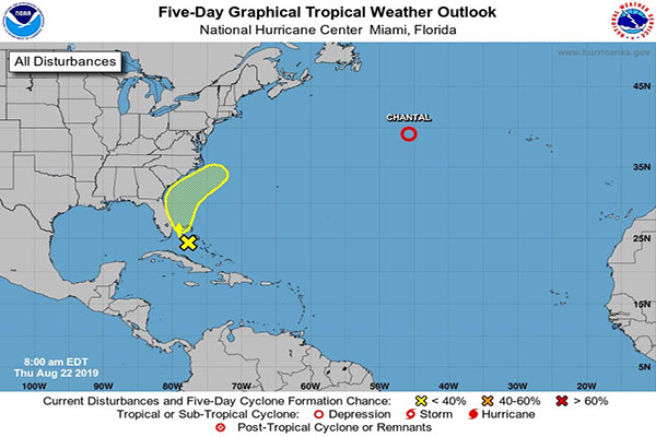
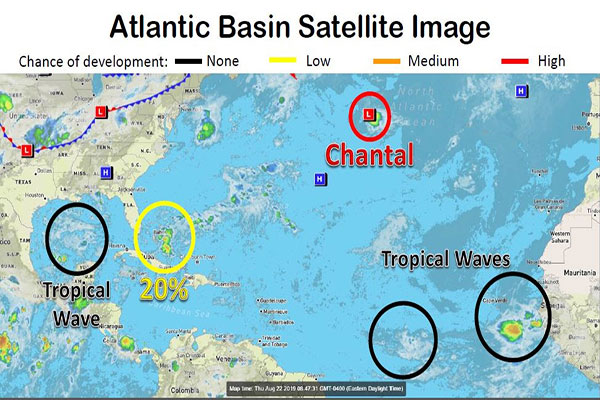
Tropical Depression Chantal is located about 645 miles southeast of Newfoundland and moving to the east at 17 mph. Chantal will likely dissipate tonight or Friday. Chantal poses no threat to Florida or the United States.
Several tropical waves are currently being monitored. The one closest to Florida is over the central and northwestern Bahamas. A significant development is not expected as it nears our area, but growth is more likely as it moves away from the state. Rain chances for east central Florida will increase Friday and through the weekend as the tropical wave approaches Florida and turns northward.
There is another one in the Gulf of Mexico and two coming off Africa. We will continue to monitor those for development.
Regardless of the hurricane predictions, Indian River County officials urge everyone to download the Official Disaster Preparedness Guide.
There are currently no threats to our local area, Florida, or the United States.