
MIAMI — The National Hurricane Center is monitoring two developing systems in the Atlantic as Post-Tropical Cyclone Gabrielle fades, with one already upgraded to a hurricane and the other poised to form a tropical depression near the Bahamas and Florida.
The Sebastian Inlet is bracing for potential rough seas of 8 to 10 feet on Monday and Tuesday as the tropical depression passes near Florida.
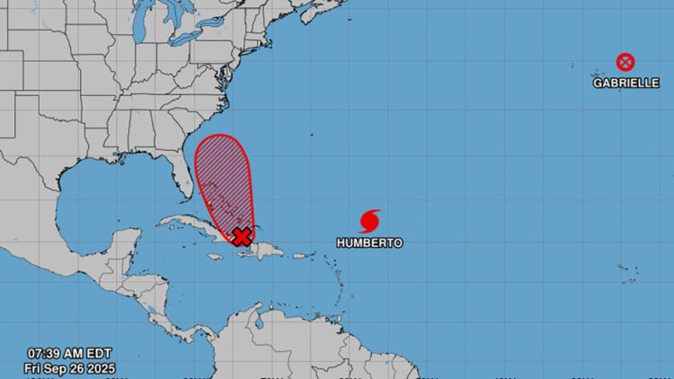
Hurricane Humberto intensified into a hurricane early Friday and is forecast to rapidly strengthen into a Category 4 storm over the next few days. The system, located east of Florida, marks the third hurricane of the 2025 Atlantic season following Erin and Gabrielle, both of which also underwent rapid intensification into major hurricanes.
Meanwhile, Invest 94L, a tropical wave near Hispaniola, the Turks and Caicos Islands, and eastern Cuba, continues to organize with showers and thunderstorms. An area of low pressure is expected to develop along the wave by tonight as it approaches the southeast Bahamas, potentially becoming a tropical depression over the weekend in the central and northwest Bahamas. The system is then projected to move northwestward or northward over the southwestern Atlantic.
Forecasters note considerable uncertainty in the long-term path and strength of Invest 94L, but warn of a significant risk of wind, rainfall and storm surge impacts along portions of the southeast U.S. coast early next week. Residents in areas including Sebastian and Vero Beach are advised to track the system’s progress. If it strengthens further, it would be named Imelda, the next storm in the Atlantic naming list.
The potential interaction between Humberto and Invest 94L adds complexity to predictions, as the two could engage in the Fujiwhara effect. This phenomenon occurs when two cyclones spinning in the same direction come within roughly 345 to 863 miles of each other, leading to outcomes such as one absorbing the other, merging into a single storm, slingshotting apart on separate paths or, rarely, combining into a larger system.
Regardless of development, Invest 94L is already bringing heavy rains and gusty winds to the Dominican Republic, Haiti and the Turks and Caicos Islands, with similar conditions likely to affect the Bahamas and eastern Cuba in the coming days. The formation chance for the system stands at 80% through 48 hours and 90% through seven days.
Preparations are urged for possible coastal flooding in Sebastian and Vero Beach, strong rip currents and beach erosion along affected areas, according to forecasters.
The Atlantic basin remains active, with the National Hurricane Center tracking the three systems amid an ongoing season that has seen two prior hurricanes.
