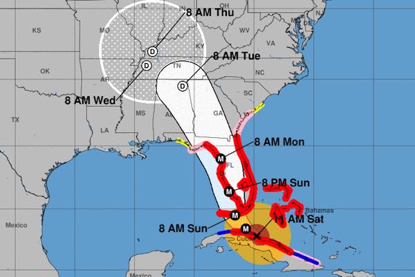
SEBASTIAN – Hurricane Irma is now a Category 3 storm with maximum sustained winds of 125 mph as the latest spaghetti models show it moving farther west, which is good news for Sebastian and Vero Beach.
Hurricane Irma spaghetti models from the U.S. GFS and the European system continues to agree on a westward path as the storm is being tracked in Cuba, according to the National Hurricane Center.
“The interaction of Irma’s circulation with Cuba has resulted in some weakening of the hurricane,” NOAA said. But the agency warns that it could build strength again before it makes landfall in Florida.
As of 11:00 a.m., Sebastian, Fellsmere, and Vero Beach is out of the projected path. This means we won’t experience hurricane force winds (sustained winds), but we will get the tropical winds. Still dangerous conditions with potential wind gusts of up to 90 mph, but better than the hurricane itself.
There is still a hurricane warning for Indian River County, affecting Sebastian and Vero Beach. Tropical forced winds are expected to be 70 to 90 mph in this area.
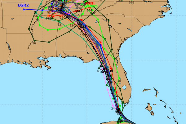
The track guidance for Irma is tightly packed and takes the hurricane over the Florida Keys and near or over the Florida Peninsula. Most of the spaghetti models, both GFS and Euro, agree on a track taking the storm up the west coast.
“The National Hurricane Center forecast is in the middle of the guidance envelope and given the good agreement among models, the confidence in the track forecast is high,” the National Hurricane Center stated.
“Once the circulation moves away from Cuba, restrengthening is forecast and Irma is expected to remain a very dangerous hurricane for the next 2 days while moving very near the Florida peninsula,” NOAA stated.
Hurricane Irma will create wind hazards in many areas in Florida that spread northward along the coast of Georgia and South Carolina where a Hurricane Watch has been issued.