Hurricane Ian’s path shifted slightly east last night and Florida is in its path, as we mentioned in yesterday’s Sebastian newscast. We can expect this storm to wobble back and forth. Forecasters are predicting a Category 3 or 4 landfall.
In Sebastian, we’ve been in and out of the “cone of uncertainty,” but it’s still too early. Ian is a large storm, about 400 miles across, and is beginning to show signs of further strengthening.
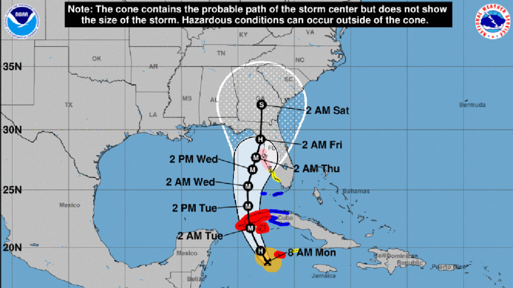
As of Monday morning, all of the tracking models agree on a path that will take Ian along the west coast of Florida.
The National Hurricane Center (NHC) said Ian would become a major hurricane on Tuesday.
“These very conducive environmental factors along with the improved structure of the storm are likely to result in rapid intensification today, and Ian is forecast to be a major hurricane when it moves near or over western Cuba tonight.”
Forecasters say Ian will become a Category 4 hurricane while in the warmer waters of the Gulf of Mexico but will downgrade to a Category 3 before making landfall. However, storm surge is still going to big problem.
Ian is moving northwest at 14 mph with maximum sustained winds of 75 mph.
In Sebastian, we are currently out of the cone of the path, but that can change. Residents should make preparations, even if we don’t get a hurricane.
Sebastian can expect tropical storm winds and up to 4 to 6 inches of rain as Ian moves into Florida. As the hurricane moves along the west coast, our weather will begin to change Tuesday night. Right now, the arrival of these winds will be sometime on Wednesday.
Sebastian Daily will keep you updated on any threats to our local area.