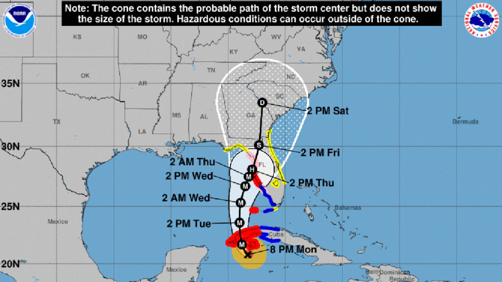
Hurricane Ian’s path is still similar to our previous report, a track that will take the major storm to Florida this week. However, computer models and forecasters aren’t sure exactly where Ian will make landfall from the Gulf of Mexico.
In Sebastian, we spoke with Mayor Jim Hill, who encouraged residents to prepare and remain calm. Hill said that as long as Hurricane Ian stays on its current path, residents should only expect some high winds and 4 to 6 inches of rain.
A tropical storm watch was issued today at 5:00 p.m. for Indian River County and Brevard County. In addition, both counties and the City of Sebastian have declared a state of emergency.
The National Hurricane Center (NHC) said Ian’s inner core appears better organized, and further strengthening is expected as it enters the Gulf of Mexico.
“Atmospheric and oceanic conditions remain very favorable for additional intensification during the next 24 h or so, as Ian moves over the very warm waters of the northwestern Caribbean Sea and the southeastern Gulf of Mexico while the shear remains quite low.”
Based on the latest forecast and timing of expected impacts, Hurricane and Storm Surge Warnings have been issued along the west coast of Florida.
According to NHC’s timeline, Sebastian, Fellsmere, and Vero Beach should feel some impact from Ian early Wednesday morning as it moves up the west coast of Florida.
Hurricane Ian is currently 130 miles southeast of the western part of Cuba. The major hurricane is moving to the northwest at 13 mph with maximum sustained winds of 100 mph.
Forecasters say Ian will become a Category 4 hurricane while in the warmer waters of the Gulf of Mexico but will downgrade to a Category 3 before making landfall. However, storm surge is still going to be a big problem.
Sebastian residents should stay informed about Ian and continue to prepare in case its path changes.
Sebastian Daily will keep you updated on any threats to our local area.